Archive for Traditional Knowledge

Constructing a hypothetical scenario for a historical statement on long term landscape changes..

The followers of Sri Ramalingam alias Vallalar might be aware of Vallalar’s statement “One day, Vadalur will become Cuddalore”. I have been thinking for long time, what it means?

The towns Vadalur and Cuddalore belong to South Arcot district (figure-1) until early 1990s, in Tamil Nadu province, India. Since the South Arcot district is very large in size, it was divided into two districts during 1991-1995. Then, Vadalur and Cuddalore became part of Vallalar Ramalinga Adigal district. The devotees of Vallalar were happy and they claimed that the Vallar’s statement came true, as the district was named in the name of Vallalar. The district name has been changed in few years’ time to Cuddalore district. For sure, Saint Vallalar did not mean this, because saints do not care about fame and name.

The saints in the past did not leave the messages clearly to the people, which raises lot of confusion among the readers in understanding their language. It is true that they say for some reason, which may take years for people to understand. With this background, I have tried to construct a hypothetical/imaginary scenario for Vallalar’s historical statement by analyzing geography and history of the region, which may not be necessarily true.

In Tamil language, “Cuddalore means the place near the sea or coast land (kadal:Sea +Voor:Place) . Vallalar’s statement “Vadalur will become Cuddalore may be a hint that sea water intrusion may bring a shore line closer to Vadalur. It may be a long term lanscape change prediction. Is this possible scientifically? I am not sure. Also I wonder, it may not happen in the near future, but may be possible after several hundred years or so. Nature is so complicated to understand or predict.

Natural hazards are powerful enough to destroy a place without any trace of people lived there, for example, a cyclone in 1964 washed a place called Danushkodi (figure-1) near Rameshwaram, thousands of people were killed, and a train was washed away with hundreds of passengers. Now there are no trace of humans lived in the place, it is like a ghost town with damaged buildings, and no one lives there at present. The Tsunami 2004 washed few villages in Tamil Nadu completely without any trace. In the history, we have studied that the old Poombukar city was submerged in the Sea. All these past experiences raises a doubt that anything can happen.

Figure1Figure-1 shows the locations of three major towns Vadalur, Cuddalore, and Chidambaram. The elevation and bathymetry of the region is also plotted. Vadalur is approximately 20 kilometers from the existing shoreline. Is it possible to have sea water intrusion for 20kms? Our human mind from the past experience will say definitely NO, as we have not seen such disastrous sea level rise or intrusion in the past 100 years. Definitely, we are not the creators of the universe, so we may not know the nature’s behavior in the future. But, the relatively lower elevation regions (highlighted in red and orange color – 2 to 5m from mean sea level) along the coast line are vulnerable for sea water intrusion and shore line changes.


Figure2You may notice a “C” type coast line seen from Cuddalore (north) to Cuddalore (south) in figure 2, the converging zone is positioned straight (same longitude) to Vadalur. There are large water bodies, canals existing in the region, closer to Vadalur from the coast. Also, the lower elevation regions <5m from MSL might be a threat. All these geographical features may pave a way for coastal water to penetrate easily into inland in the next century or several century later. Such havocs situation may convert the Vadalur, an inland town to a coastal town.


At the same time, Chidambaram is located closer to the coast than Vadalur. So, the threat is same for Chidambaram too?  NO, from my opinion.  Chola Kings are amazing visionaries in locating and constructing temples at a right place for having long standing temples, more than thousand years. Lord Nararaja temple in Chidambaram is one of the important architecture work by early Cholas and later many have contributed to this temple including pallavas, cheras, later cholas etc.,. Even, Vallalar was so much attached to this temple. This raises a question to me, how protective the Chidambaram temple is from coastal hazards? Look at the figure-2, there are mangroves located straight to the temple along the shore line. The mangroves which we see is the current extent, which may be more in the past. Mangroves are protective enough for this temple and people in the region. These mangroves protected few villages from tsunami 2004. Now many countries are planting and preserving mangrove forest to protect from the coastal hazards. Hence this may be a reason, why Vallalar did not mention about Chidambaram in his statement. Our ancestors were very much aware of geography for establishing new settlement places, agriculture activities, water management structures and other activities.
19th Century Climate Scientist’s article on “Formation of rains”

Sri Ramalingam’s piece of work during 19th century on “how rain forms” is an extra-ordinary scientific work considering the time he had written without even having a primary school education. May be this piece of work is to clarify the doubt among the people on “how rain comes?”, as people had a wrong belief (according to him) that “Cloud consumes ocean water to form rain” 

AtmosVallal


Here is the rough translation of his work

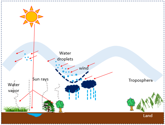
  • Due to the energy from sun (Solar insolation), the water content from vegetation, water and land is sent to troposphere as water vapor (vaayu mandal), (due to evaporation/evapo-transpiration)
  • As the vapor content moves up and stays as a warm layer in troposphere, the water vapor contents gets condensed and forms as water droplets (clouds).
  • Due to the wind movement (seasonal varying winds), the thickness of the warm troposphere layer loosens (may be due to density of water droplets and also the gravity), then lightning comes, followed to that thunderstorm comes, then cloud condenses (also affected by wind movement), then rain comes to the land.

Highlights

I do not know when the physical mechanism behind the rain is identified, may be 20th century or even before? Whereas, the importance of land atmosphere interaction is getting more attention among the climate scientist for past 2 or 3 decades. It is astonishing to note that he has recognized the importance of biosphere (vegetation, land and water) in the process of rain formation during 19th century.

At present, we know about wind movement and tropospheric layers through satellite observations, and also how the seasonal wind pattern changes during different months. It is really a mystery, how he could say this line “seasonal varying winds movement in the troposphere layer”

His information on role of solar insolation, troposphere, condensation, evaporation/evapo-transpiration, clouds, lightning, thunderstorm etc., are great scientific contribution to that time. I am not sure, how many has recognized his scientific aspects in his work during late 19th or even early 20th century. Many of his works are not so easy to understand, as he is not just a poet, he is more than that (for me, he is a great scientist).

Original version in Tamil

“இதுபோல் சூரியகிரண (Sun rays) உஷ்ண ஆவியாகிய புகை ஓஷதிகளிலும் (Vegetation) நீரிலும் பாரிலும் பொருப்பிலுமுள்ள திரவசக்தியைக் (Water content) கிரகித்து, வாயுமண்டலத்தில் (Troposphere) சேர்த்து, மேலுங்கீழும் உஷ்ணம் நிரம்ப, மத்தியிலுள்ள திரவ (vapor content) அணுக்கள் புழுங்கி நீராய் (condensed water vapor or clouds), காலபேத வண்ணம் (seasonal varying) வாயுவால் (wind) பிரேரிக்கப்பட்டு அசைக்கும்போது, கீழுமேலுமுள்ள உஷ்ணவாயு தடிப்பு (warm pressure layer thickness) விலகும்போது, மின்னலாகிய பிரகாசமும், நெருங்கி யொன்றுபடும்போது சத்தமாகிய இடியும், அத்தொனியால் படலம்போல மூடியிருந்த காராகிய மேகம் விலகி வாயுவால் கலங்கிய போது மழையும் உண்டாகும். இதன்றி, மேகம் கடல் ஜலத்தை உண்டு மழைபெய்வ தென்பது பொய்.”

–    Sri Ramalingam (Most of his works are done between 1853 – 1874)

Veeranam tank – A Chola’s water management plan in 10th Century is worth more than 200 million US$ in 2014

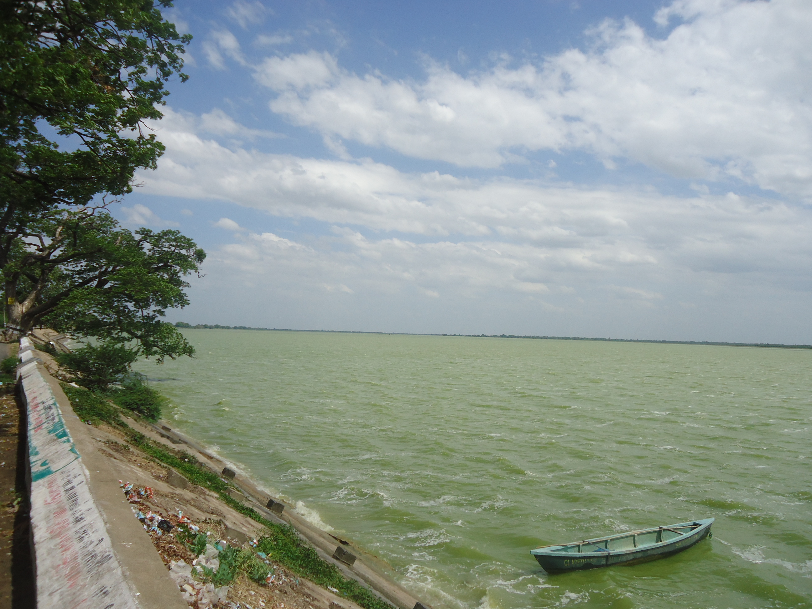
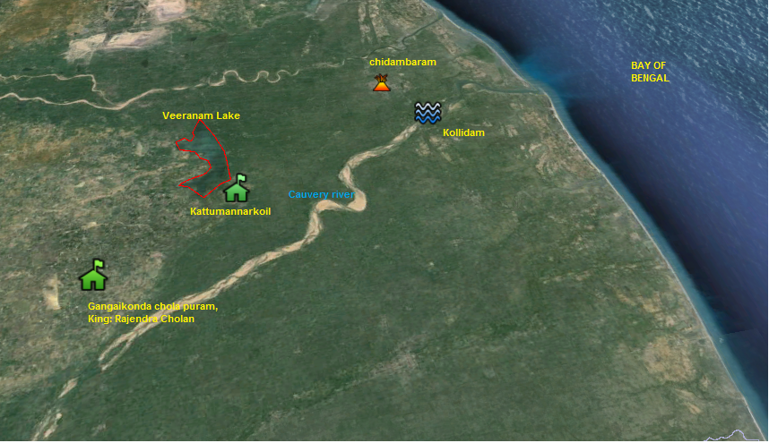
Veeranam tank/lake, was built by the famous Chola king Rajadityan son of Paranthaka Cholan during 10th century AD, is one of the classical example of Chola’s water management plan. This lake stores the excess water from the tributaries of Cauvery River flowing into Bay of Bengal and supports the region for agriculture activities. This lake protects against the flood by storing the excess water. The lake area is approximately 23 sq.km and has a capacity to store about 1,465 million cft of water. More than 20,000 acres of agriculture lands are getting irrigated from Veeranam lake. It is astonishing, how in ancient days, they had designed such a nice water management structure, which still works great.

VeeranamTank

(Google Map Showing Veeranam tank and adjacent areas)

DSC02984


(A view of Veeranam Tank from Kandakumaran Village, Kattumannarkoil Taluk, Tamil Nadu)

A Government Order of Tami Nadu 2011 indicates, for deepening Porur tank 1m to 2m, to increase the capacity from 46 to 70 mcft, estimated cost was around Rs. 20 crore. Think about the cost of constructing a new Veeranam tank, which has 1465 mcft capacity. Rs. 20 Crore was estimated in 2011 for increasing the structure capacity of 24mcft. For 1465 mcft, we might need to spend Rs. 1126 crores which is approximately 191 million US$ based on 2011 estimates. May be approximately 200 million US$ in 2014. This is just a construction cost after the land got procured. If we estimate the benefits of agriculture in the region, drinking water supply to Chennai city, several millions of dollars has to be added.

“People and the government should not think that they got this infrastructure for free. They have to remember that the value is 200 million US$ and every year they should spend atleast 1million US$ (0.5%) to maintain this precious Veeranam tank to store enough water, so that the ground water recharge will also be significantly improved in the region”

________________________________________________________________

Though my birth place is Kattumannarkoil and have seen this great lake hundreds of times, I have never realized it’s importance in the past. This lake is referred as Veera Narayana lake in the famous tamil novel called “Ponniyin Selvan”

Seasonal climate forecasting in ancient days

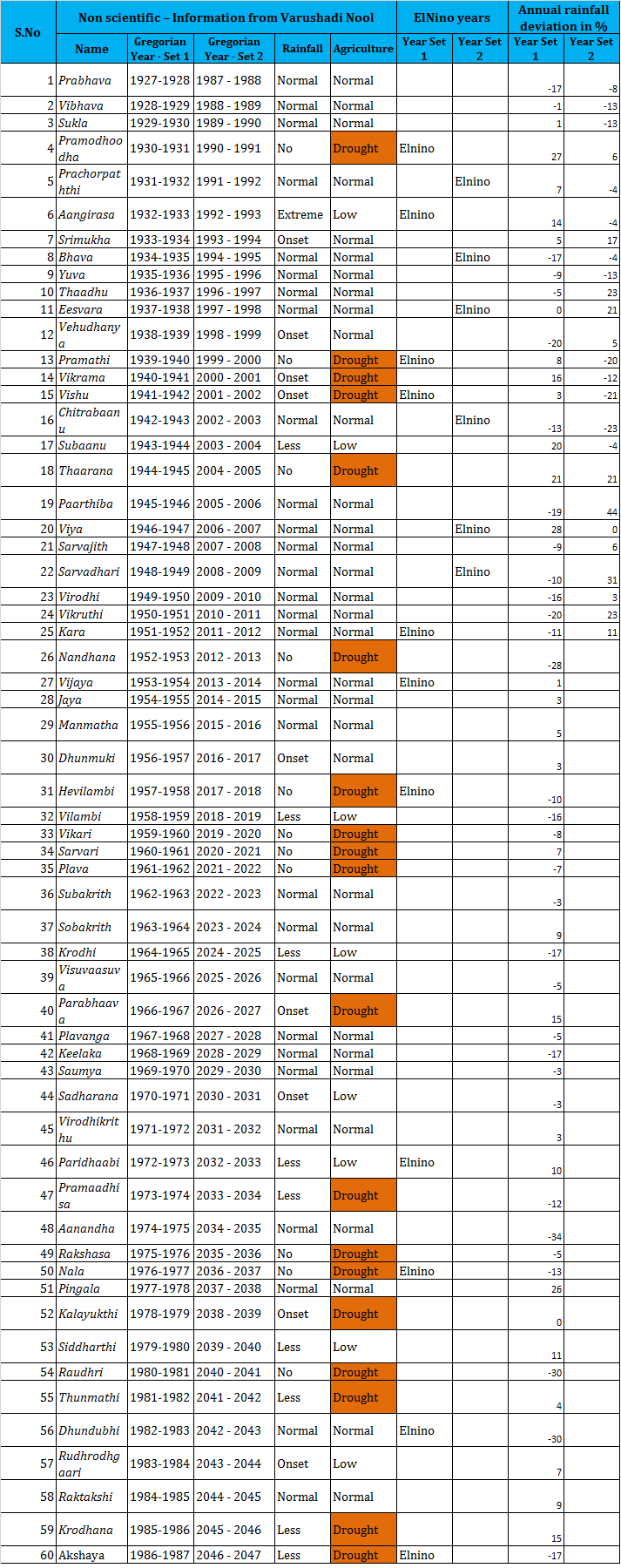
Advanced climate modeling and forecasting techniques are in place for the past two decades. However for many decades, the farmers in rural Tamil Nadu were using traditional climate forecasting ways to understand the climate characteristics well in advance through sky observations and a book called “varushaadi Nool” (varushadi – year, Nool – Book) written by ancient saints. The varushaadi nool has details on rainfall and agricultural yield for 60 years cycle (see table below). Farmers read the book (Varushaadi Nool) on April 14, which is the starting of tamil new year to know about the rainfall characteristics and agriculture yield for the upcoming crop season.

Some farmers, Observe the cloud pattern during the full moon day of Chitirai month (14Apr to 13May) to predict the seasonal rainfall and it became accurate for most of the times. The cloud pattern on full moon day of Chitirai month (14Apr to 13May) and varushaadi nool helps them to understand the rainfall characteristics and crop yield well ahead of time to be prepared mentally for the uncertain situations.

The translation of the songs in varushaadi nool for 60 years are presented in the below table. Just to validate, how our traditional knowledge worked in the past. I have added El Nino years and rainfall deviation (for Tamil Nadu) in the table. From 1926 to 1986, most of the Elnino years were matching with “Varushadi Nool” drought years. Some of the drought years were matching with varushadi nool. But at the same time it fails to predict from 1987. This might be an indication of the change in climate pattern which was not foreseen by the ancient saints or I do not know. However it has to be further investigated to have some interesting results. This nonscientific method of climate forecast somehow fits with scientific observations too.

Table: Rainfall and Agriculture characteristics from Varushadi Nool

Varushaadi

Deforestation and Disaster preparedness in Thiruarutpa

“Scientific information in ancient Tamil literature THIRUARUTPA”

Sri Ramalingam (alias) Vallalar, wrote Thiruarutpa (www.thiruarutpa.org) in 19th century, which is famous literature for spiritual principles. However, many scientific information could be observed in his works. This makes us to think, how amazing people lived in the pre ICT era. The valuable information from ancient literature’s could be used as proxy/reference for validating some of the research studies

The forest lands has been converted into agricultural lands for feeding the growing population. Scientific community (Ecologist, climatologist, bio geographers, etc.,) has been telling that deforestation is one of the threat for our planet earth, as losing forest might warm the earth and alter precipitation patterns. There are so many impacts related to the deforestation, which I will not discuss in detail.

Here are the lines from Thiruarutpa (tamil literature), which says about deforestation trend in the ancient days.

“ காடுவெட்டி நிலந்திருத்திக் காட்டெருவும் போட்டுக்

கரும்பைவிட்டுக் கடுவிரைத்துக் களிக்கின்ற உலகீர்…” Thiruarutpa, Sixth Thirumurai, Section 105, Song 2

Translation – “ You (people) are cutting forest, converting land, applying fertilizer, cultivating sugarcane, and enjoying…”

It has been clearly indicated that people living in 19th century are converting forest lands into agricultural lands. This is what we talk in the scientific language, deforestation and land use conversion.

Here are the lines on disaster preparedness:

“ஆற்றுவெள்ளம் வருவதன்முன் அணைபோட அறியீர்” Thiruarutpa, Sixth Thirumurai, Section 105, Song 3

Translation – “You do not know to make bund/embankment before the river flood comes …”

This poem highlights the evidence of hazards such as floods in those days in Tamil Nadu (mostly cuddalore district or cauvery delta region, where the author lived). Also, the song highlights lack of disaster preparedness in ancient days. Preparedness is very important to protect lives and properties from natural hazards such as Floods..